
NC Wyeth Map 1927
One of my favorite childhood memories was sitting on the floor in a sunny spot next to the radiator in my grandfather’s study looking at his stacks of National Geographic. In my youth we had not yet experienced the explosion of images that now make the exotic seem ordinary. Then, the bare-breasted ladies or mysterious women in chador with henna painted hands or Chinese roofs seemed almost unendurably romantic, strange and so fascinating. I unfolded the large, wonderful map that came in every issue. I spread it out in front of me and my five-year-old self went fearlessly everywhere the world had to offer. Even today, I can’t resist a map. A map contains a huge expanse of possibilities. Put a globe in front of me and I am gone for hours, tracing routes and turning it slowly. This is a love that may flicker in life’s course, but then returns in full force at a chance encounter.
Just such a moment occurred for me when I stopped in the Monckton Gallery in Hubbard Woods to ask Nancy Monckton what was her most powerful, personal experience with a work of art for an article that I was writing. She said without hesitation, “The Field Museum’s recent show of antique maps!”
“The Festival of Maps was a celebration of cartography through the ages. The Queen’s Collection, the Bodleian Library at Oxford, the Bibliotheque Nationale of Paris contributed. From Michelangelo to Rand McNally, these maps provided the opportunity for people to travel from the ancient world to mythical lands, and from the celestial heavens to the depths of Hades. There were centuries old manuscript maps drawn on cloth, maps hand carved into primitive artifacts, and maps hand engraved into blocks of wood or copper plates, multi-dimensional topographic maps and GPS systems.” Nancy enthused.
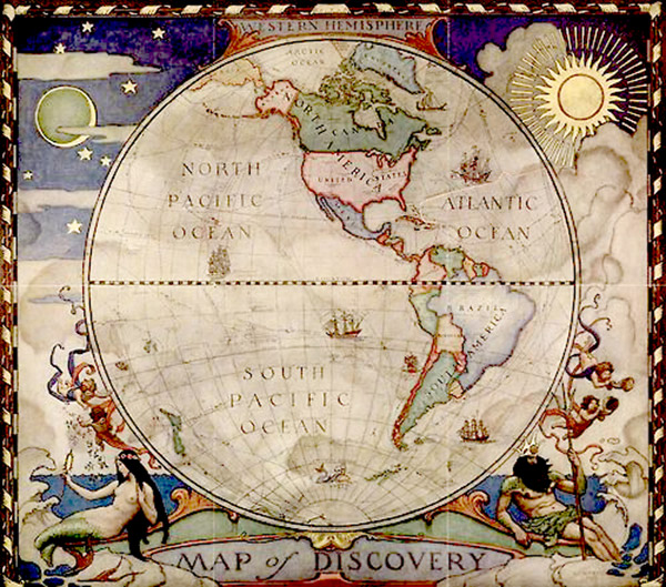
She showed me some of the examples in her own collection including two from NC Wyeth that National Geographic Society had commissioned in the late 1920s. They were so beautiful with Poseidon and many other mythological references. There was also an original print from Ortelius’s Atlas in 1570/75 seemed amazing to me. The color, four and half centuries later, is still so vivid. The two brilliant copperplates used to reproduce Rusch’s map from 1508 is spectacular. The engraver was as much an artist as the original draftsman.
Questions like how did they know, when did they know, how did they get it so right, raced through my mind. Nancy said that I had to speak to her husband Jack who is very knowledgeable in historical geography. Jack explained to me that it may have been artists that drew these wonderful works from explorer’s descriptions and the sketches of artists who may have gone along, but it was royalty and commercial enterprises that paid for them. Wars and trade routes are still big business. “You have to know where things are and how long it will take to get there and back.” He went on to explain dead reckoning, positional fixes, and other elementary but effective tools that have been used since a man’s foot gave us distance.
Antique maps are as decorative as any print or graphic. The prices cover a wide range from a wonderful calendar of the celestial bodies at bookstores for $5.95 to EBay’s NC Wyeth reproductions, to the exquisite antique maps that are available from Monckton Gallery and, many local antique stores. The Field Museum is a magnificent resource. With suitable framing these maps are sensational conversation pieces and stimulating art for children of all ages.